
Gain subsurface insight with Leapfrog Works. Dynamic 3D geological modelling designed for civil engineering and environmental projects.
Vendor
Seequent
Company Website
Overview
Turn complex data into clear, easy to interpret visualisations
Leapfrog Works helps you visualise and understand your data so you can communicate risks with stakeholders of all technical levels – and make better decisions on all your civil engineering and environmental projects.
Save time for analysis
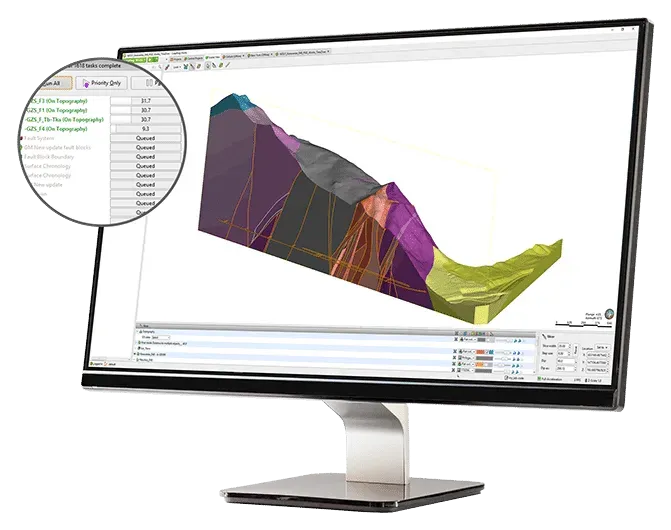
Change how you look at and work with data using streamlined workflows. Generate cross sections rapidly and use tools that integrate your models with engineering designs. Increase the productivity of your 3D subsurface modelling with rapid creation and updating of geological models. As new data is input, your models and outputs (such as cross sections) dynamically update without needing to recreate them, saving both time and money. 3D subsurface modelling offers an unrivalled level of accuracy and efficiency in understanding ground conditions. Better identify and assess risks at every stage of the project lifecycle and spot challenges early on.
Communicate clearly
Seeing subsurface insights in 3D brings clarity to even complex data, giving you a higher level of understanding. Highly visual 3D subsurface models help you better interpret ground conditions. Clearly communicate risks to all stakeholders using free visualisation tools, including, Leapfrog Viewer, and movies, and export high quality images and section layouts for reports and presentations.
Collaborate with all teams
Leapfrog Works supports industry-standard ground investigation data formats. You can also combine your geological models with engineering designs, BIM workflows, and groundwater flow models, to see the complete picture of your project. Give geologists a seat at the table when making critical decisions on ground conditions. Combine your Geological Information Model with your Building Information Models and enable collaboration with other teams to develop an Infrastructure Information Model.
Features
Dynamic 3D modelling
Easily copy and build multiple models to explore various hypotheses and then update them dynamically with your latest information. Automatically add new borehole data while parameters hold true. Create static models for comparison and reference. Spend less time building models and more time interpreting and sharing.
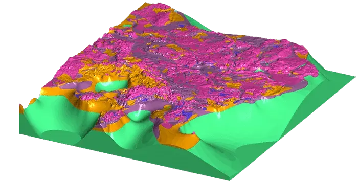
Ground type classifications
Rapidly build 3D geological and numeric models from a wide variety of data sources including borehole, structural, GIS, 2D grid, map, point, polyline, mesh/surface, historical cross section data, geotechnical investigations, well screens, or points. Apply an array of modelling methods and powerful intuitive interpolant controls. Perform structural modelling and use borehole planning tools. Combine rock mass ratings, soil behaviour, or contaminant concentrations with geological domains for combined ground type classifications.
Collaboration and sharing
Easily share your cross sections, images and movies, interactive 3D scenes, BIM, and CAD data outputs, not only enhancing productivity but your understanding. Visualise and share projects rapidly with Central for better workflow and communication, allowing everyone from technical staff to non-technical stakeholders to understand what the data is saying.
Interoperability
Connect directly to OpenGround Cloud platform to access your single source of geotechncial data. Easily import and export geotechnical and geoenvironmental data to specialist software packages, including GIS data from Esri geodatabases and shapefiles, Map Info, or raster images and maps. Export seamlessly in industry recognised BIM formats and publish directly into the BIM environment. Integrate Drawing eXchange Format (DXF), Civil3D, and AutoCAD Drawing (DWG) formats from Autodesk.
Engineering designs
Don’t wait for the CAD department to process your job, work directly with your engineering data in the geological context model. Rapidly visualise and understand detailed tunnel, motorway earthworks, bridge, dam and building foundation designs in geological context. Integrate designs, build surface topography, and create excavation volumes to inform design. Import alignments and create longitudinal sections, fast.
Environmental insight
3D geological modelling makes it easy for you to build geology and initial values for groundwater flow simulation. Rapidly assess contaminant plumes or saltwater intrusion by combing geological models with water sample screens or geophysical data. Model directly from screens in AGS or gINT projects. Visualise plumes or saltwater wedge intrusion in 3D. Then, use the Hydrogeology Solution Kit to easily combine with flow models.
Generate cross sections
Make sections anywhere on site in minutes, not hours. Visualise from any angle, turn, rotate, and rapidly detect errors. Work intuitively with tools that help you advance your analysis and recognise correlations and trends. Update dynamically as the model evolves. Import historic sections and maps. Tailor outputs for reports, CAD, or geotechnical analysis.
Hydrogeology Extension
Use this optional kit to incorporate MODFLOW and FEFLOW flow models to further reduce your risk. Easily use lithology models as the basis for flow models to visualise modelling results. Import, create, and assign properties to MODFLOW and FEFLOW grids/meshes from your subsurface model. Visualise grids in a 3D scene and share your models with free tools Leapfrog Viewer.
Contaminants extension
Bring contaminant data directly into your Leapfrog Works 3D geological models. This intuitive, interactive extension allows you to characterise, visualise, and create auditable estimates of contaminant mass and location in land and groundwater environments.