
GPS ConnectTransfinder
GPS Connect provides your district with an analytical tool beyond compare. Only Transfinder’s mapping technology can harness the power of real world latitude and longitude coordinates.
Vendor
Transfinder
Company Website
GPS_Connect-165432.pdf
Product details
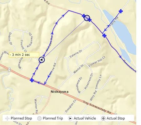
GPS Connect by Transfinder is a powerful GPS tracking solution designed to provide school districts with unparalleled visibility and control over their transportation operations. Formerly known as Busfinder, GPS Connect integrates seamlessly with Routefinder Pro, displaying real-time and historical GPS data alongside planned routes on the same map. This enables transportation managers to monitor bus locations, compare actual versus planned routes, and make informed decisions to improve efficiency, safety, and cost-effectiveness.
Features
- Real-Time & Historical GPS Data: View live bus locations and historical path-points simultaneously with planned route data.
- Comparative Analysis: Compare actual driving paths with planned routes to identify variances and optimize performance.
- Map Maintenance: Use GPS data points to update maps even before county maps are refreshed.
- Driver Behavior Tracking: Monitor speed, stop times, and idle times to improve safety and reduce fuel consumption.
- Alerts & Notifications: Set parameters for alerts on speed, stop variances, and timing; receive electronic notifications for out-of-the-ordinary events.
- Idle Time Monitoring: Reduce carbon footprint and fuel costs by tracking and minimizing idle times.
- Trip Creation from GPS Events: Implement and modify routes quickly based on GPS data for faster operational adjustments.
- Integration with Leading GPS Vendors: Compatible with hardware units from most major GPS providers for easy implementation.
- Customizable Visuals: Highlight critical grid information in customizable colors for urgent matters.
- Live & Historical Playback: Watch buses in motion or review past data to verify schedules and analyze performance.
- Enhanced Mapping Tools: Add/edit streets, reposition stops, and accommodate new developments or construction using GPS insights.
Benefits
- Improved Accuracy: Validate routes and schedules using real-world GPS data for precise planning.
- Operational Efficiency: Quickly adjust routes and stops based on actual driving conditions and GPS feedback.
- Cost Savings: Reduce fuel consumption and idle times to lower operational costs and environmental impact.
- Enhanced Safety: Monitor speed and route adherence to ensure compliance with safety standards.
- Proactive Management: Receive alerts for deviations and address issues before they escalate.
- Rapid Implementation: Benefit from quick setup and training for immediate ROI on GPS investment.
Find more products by industry
EducationTransport & StorageProfessional ServicesPublic AdministrationView allFind more products by category
Travel SoftwareEnterprise Resource Planning (ERP) SoftwareAnalytics SoftwareView all